A rapidly developing area of low pressure will continue to drift off to the northeast Sunday. Widespread moderate rain will fall in areas east of the Mississippi River. As the system continues to strengthen and pull away, winds will shift to a more northerly direction. This northwest wind will usher in enough cold air before the precipitation ends to see the frozen variety. Much of the rain will transition to moderate snow by Monday, with several inches likely. The key to how much snow falls and where is falls will depend on how quickly the cold Canadian air works its way in. The image below is the EURO model's take on where the all important 0C line will set up at 850mb, it is the solid blue line. While this model has the freezing line ahead of the precipitation, not every model does. This is a tricky forecast, but confidence is on the rise of the snow accumulation solution above. Many areas that see snow will be in the 3-4" range, but bands of heavier snow and thunderstorms rotating into the cold air could send isolated amounts to 6" or 7"!
A little weather from a meteorologist, and a little golf from a golfer
ShareThis
Sunday, November 23, 2014
Sunday, November 16, 2014
HEAVY Lake Effect Snow on the Way
Saturday, November 15, 2014
Near Record Cold, Followed by a Possible Pattern Change
We are currently stuck in a pattern similar to last winter. Warm air/water in the North Pacific which sends a ridge into Alaska and a trough into the eastern part of the United States. This pattern is a direct result of once Typhoon Nuri, More details. Think of it as when you send a ripple through a rope and a wave forms. The wave travels through the whole rope, the same is true in atmospheric waves. This pattern has allowed cold air in Canada to filter south for roughly a week now. It looks to continue through the next week.
Above is the geopotential height anomalies, with a lower departure from average in green and higher values in red and purple. For simplicity the lower values can be though of as the location of a trough and the higher values thought of as a ridge. The image on the right shows the surface temperatures compared to normal, notice the expansive cold in just about all of the country on Tuesday. A direct result of the trough and ridge pattern, plotted above from the ECMWF model.
Another cold night to be expected for Monday into Tuesday as the GFS model is plotting temperatures near zero as much of the Midwest wakes up on Tuesday morning. Winds chills will will be 10-15 degrees colder than the temperatures plotted here. It will certainly feel like winter, if it has not already! A special thanks goes to a now several inch snow pack across the region, which will allow for incoming solar radiation to be reflected back into space, instead of being spent to warm the surface, as snow has a high albedo than vegetation.
A pattern change?
Some models are now hinting at the idea of a relative pattern change that would leave the United States warmer than it has been. Most of the major oscillation indices are going to a neutral pattern. This makes sense with the zonal flow plotted from the ECMWF plot on the right of geopotential anomalies. The NAO, AO, EPO, WPO all sit at neutral or close to in about a week. While this does not mean it will be warm, it does mean that we can expect more normal temperatures in about a week, after yet another arctic week of chill.
The "pattern change" could spawn a couple snow storms, or snow events across parts of the Midwest. The 10 day snow forecast off the GFS is plotted on the left. While this should not be a used as an exact forecast, it does show what is capable by the atmosphere over the next week plus. Three systems are possible, with next Friday and next Tuesday stealing the show. More details will posted in the coming days if these storm pan out. Stay tuned!
Above is the geopotential height anomalies, with a lower departure from average in green and higher values in red and purple. For simplicity the lower values can be though of as the location of a trough and the higher values thought of as a ridge. The image on the right shows the surface temperatures compared to normal, notice the expansive cold in just about all of the country on Tuesday. A direct result of the trough and ridge pattern, plotted above from the ECMWF model.
Another cold night to be expected for Monday into Tuesday as the GFS model is plotting temperatures near zero as much of the Midwest wakes up on Tuesday morning. Winds chills will will be 10-15 degrees colder than the temperatures plotted here. It will certainly feel like winter, if it has not already! A special thanks goes to a now several inch snow pack across the region, which will allow for incoming solar radiation to be reflected back into space, instead of being spent to warm the surface, as snow has a high albedo than vegetation.
A pattern change?
Some models are now hinting at the idea of a relative pattern change that would leave the United States warmer than it has been. Most of the major oscillation indices are going to a neutral pattern. This makes sense with the zonal flow plotted from the ECMWF plot on the right of geopotential anomalies. The NAO, AO, EPO, WPO all sit at neutral or close to in about a week. While this does not mean it will be warm, it does mean that we can expect more normal temperatures in about a week, after yet another arctic week of chill.
The "pattern change" could spawn a couple snow storms, or snow events across parts of the Midwest. The 10 day snow forecast off the GFS is plotted on the left. While this should not be a used as an exact forecast, it does show what is capable by the atmosphere over the next week plus. Three systems are possible, with next Friday and next Tuesday stealing the show. More details will posted in the coming days if these storm pan out. Stay tuned!
Friday, November 14, 2014
Thursday, November 13, 2014
Over 4 FEET of Snow in Northern Wisconsin
Thanks to the NWS-Duluth for the storm report. Needless to say, we did not fully forecast 4'+ of snow! Most of this rapid accumulation is due to lake effect bands, associated with the surface cyclone as is continues to push off to the northeast!
A couple inches of snow are likely Saturday into Sunday from Iowa to Wisconsin and Illinois, as a weak trough passes through the area. Temperatures continue to stay cold with strong blocking in the North Pacific.
Sunday, November 9, 2014
Crippling Winter Storm Monday
For millions, this will be a storm to remember. From Minneapolis to Marquette, Michigan there is a potential that this snow could last the entire winter. We are heading into a pattern of well below normal temperatures after this storm passes.
The cyclone is still developing in Rocky Mountains and will begin to emerge later today and pass through the Midwest Monday into Tuesday. Much of the area is under winter storm watches and warnings in anticipation of heavy snow that will alter usual travel. From central Minnesota to northern Wisconsin, school will certainly close Monday and/or Tuesday. Confidence is very high on the track of the system and the intensity, as every major computer model has now sampled the system as is pushed on shore this morning. All of the solutions presented by the models are extremely similar and only very on a track of 5-15 miles. The sharp cut off in heavy snow we are forecasting does not make for an easy forecast, as 10 miles will have a major difference in how much snow falls. Any necessary tweeks to the forecast will be posted on Facebook and in a new post on this site. By Tuesday, over a foot of snow will have fallen in northern Wisconsin, which will set up for a cold week ahead. Any nights will clear skies and light winds will feature temperatures near zero where a significant snow cover is now in place. In summary, winter is here and will stick around for awhile. Many snowfall records will certainly be broken by Tuesday. Take it easy if you plan to travel in the effected area, and keep it here for continued updates on this winter storm and the winter to come.
Saturday, November 8, 2014
MAJOR WINTER STORM MONDAY
The winter storm we have been talking about for several days now is going along as planed. The track has shifted slightly north, but amounts and strength of the system have not budged in the past 3-4 days. Model consistency between today's runs and today's models is very good, with the NAM being a northerly out layer. The GEM model actually has a solution similar to runs done on Friday, where the axis of heavy snow is set up from Milwaukee to Detriot. However, we expect this model to conform to the northward trend in the coming runs.
Amounts vary somewhat in the models, but generally a solid area of 6-12" is likely, as shown above. A pocket of strong forcing and convergence will create a band of 10"+ that will likely set up in northern Wisconsin. Winter storm watches are already posted (see map on left) for the first winter storm of the year. These watches will switch over to warnings by Sunday night and the storm approaches. This is a classic spring time winter storm set up, with warm moist air to south crashing into cold Canadian air in the north, below are the forecasted highs from the ECMWF computer model.
The main question in this system will be what happens as the actual area of low pressure passes through Monday night and Tuesday. Models are not putting much snow down in Iowa and southern Wisconsin Monday night, but with a ~1000mb low pressure and cold air wrapping in by that time, the atmosphere will be conducive for a few inch of snow as it pulls away to the northeast.
Be sure to keep it here to Midwestweather, for updates on the storms and any tweaks that may be necessary to the snow map.
Friday, November 7, 2014
Where Will this Heavy Band of Snow Set Up?
The track of the system, always the million dollar question when it comes to winter storms and snowfall associated with them. The track and position of baroclinicity will be the major wild card in the system on Monday. A couple days ago most of the major computer models had the band of heavy snow setting up along an axis near the WI/IL border extending eastward. In the last few runs the common trend is to shift north with each run. However, the GEM and some WRF model runs still have central Iowa and southern Wisconsin in the bulls eye.
What we know:
- A band of 5-9" of snow will set up somewhere in the Midwest, most likely case in the darker blue
- It will be cold enough to support a light fluffy snow, most of the precip will be in the form of snow
- Models will continue to wobble back and fourth on a solution to the track
- Significant gulf moisture will be available for the storm to tap in to
- Extreme cold will be ushered in on the back side of the cyclone, by Tuesday and Wednesday
What we are uncertain about:
- The track, while we have a general consensus, we will know more tomorrow!
- Extent of cold air, if the air mass cools more than predicted a southern shift is possible
- Banding of heavier snow, will an area of deformation set up, or will we see a broad area of 4-7" instead of a narrow area of 7-10"
- Will a secondary round of snow develop with the surface cyclone, as the 12z ECMWF has? this could lead to more widespread accumulations
Be sure to check back for continued updates
What we know:
- A band of 5-9" of snow will set up somewhere in the Midwest, most likely case in the darker blue
- It will be cold enough to support a light fluffy snow, most of the precip will be in the form of snow
- Models will continue to wobble back and fourth on a solution to the track
- Significant gulf moisture will be available for the storm to tap in to
- Extreme cold will be ushered in on the back side of the cyclone, by Tuesday and Wednesday
What we are uncertain about:
- The track, while we have a general consensus, we will know more tomorrow!
- Extent of cold air, if the air mass cools more than predicted a southern shift is possible
- Banding of heavier snow, will an area of deformation set up, or will we see a broad area of 4-7" instead of a narrow area of 7-10"
- Will a secondary round of snow develop with the surface cyclone, as the 12z ECMWF has? this could lead to more widespread accumulations
Be sure to check back for continued updates
Record Breaking Cyclone Near Alaska to Bring Winter Temperatures to Midwest
The remnants of Typhoon Nuri will have a major impact on the overall pattern in the United States next week. The cyclone passing west of the Aleutian Islands is forecasted to reach a mean sea level pressure of near 920mb, a would be record in the Northern Pacific! Damaging winds and waves in excess of 50' will be the norm across the area over the next few days as this powerful system drifts off to the north and east. Cyclonic winds around the center of the system will usher in warm Central Pacific air into Alaska over the next several days as this southerly flow hold its ground.
In turn, the jet stream will be bumped north and an amplification in the jet steam will occur in the Northern Hemisphere. With a massive ridge over Alaska, a substantial trough will then result over much of the United States. This feature will allow the otherwise locked up Canadian air mass to dive southward by the middle of next week. The colder air will begin to push into the United States by Monday and Tuesday, with the furthest extent of the arctic blast coming in on Thursday. For a detailed description of the cold Click Here!.
While Alaska will see well above normal high temperatures, the Midwest will see temperatures on par with those of mid January. The CPC agrees, here is there 6-10 temperature outlook, on right.
In turn, the jet stream will be bumped north and an amplification in the jet steam will occur in the Northern Hemisphere. With a massive ridge over Alaska, a substantial trough will then result over much of the United States. This feature will allow the otherwise locked up Canadian air mass to dive southward by the middle of next week. The colder air will begin to push into the United States by Monday and Tuesday, with the furthest extent of the arctic blast coming in on Thursday. For a detailed description of the cold Click Here!.
While Alaska will see well above normal high temperatures, the Midwest will see temperatures on par with those of mid January. The CPC agrees, here is there 6-10 temperature outlook, on right.
Thursday, November 6, 2014
Mid January Like Cold on the way for Mid November
By the middle of next week much of the midwest will observe highs on par with the average high temperature in mid-January! With snow cover on the ground, these temperatures could plummet even further. The snapshot on the left is the forecasted wind chills for Thursday morning! The gray area of below zero wind chills will depend on where a band of accumulating snow sets up for Monday and Tuesday, the latest on that can be found at: Winter Storm Update.
Even without the snow cover, wind chills will creep around 0 degrees!
The extreme cold, for November, will encompass much of the eastern half of the country with well below normal temperatures. 850mb temperatures are around -15C for much of the Midwest (see map for your location). Temperatures this low at 850mb would translate to high temperatures in the 20s, which appears to be the rule of thumb across much of the Midwest Thursday. Add 6" of snow and highs could be stuck in the teens for parts of the Midwest by the middle to end of next week! Wow! Some values during the afternoon may be colder than the average high temperature in January.
Wednesday and Thursday appear to be the coldest days, with the brunt of the Canadian airmass centered over the Midwest. The plot on the left shows the high temperatures forecast by the 00z ECMWF run last night. Widespread 20s are very likely, the GFS among other models are painting a similar picture across the Midwest. After a Monday into Tuesday winter storm and substantial cold, it will certainly feel like winter by this time next week, bundle up out there!
No matter the exact high, temperatures will run 15-25 degrees below normal during the middle of next week. The CPC agrees, below is their 6-10 day temp outlook:
Even without the snow cover, wind chills will creep around 0 degrees!
The extreme cold, for November, will encompass much of the eastern half of the country with well below normal temperatures. 850mb temperatures are around -15C for much of the Midwest (see map for your location). Temperatures this low at 850mb would translate to high temperatures in the 20s, which appears to be the rule of thumb across much of the Midwest Thursday. Add 6" of snow and highs could be stuck in the teens for parts of the Midwest by the middle to end of next week! Wow! Some values during the afternoon may be colder than the average high temperature in January.
Wednesday and Thursday appear to be the coldest days, with the brunt of the Canadian airmass centered over the Midwest. The plot on the left shows the high temperatures forecast by the 00z ECMWF run last night. Widespread 20s are very likely, the GFS among other models are painting a similar picture across the Midwest. After a Monday into Tuesday winter storm and substantial cold, it will certainly feel like winter by this time next week, bundle up out there!
No matter the exact high, temperatures will run 15-25 degrees below normal during the middle of next week. The CPC agrees, below is their 6-10 day temp outlook:
Midwest Winter Storm Potential! An Update
Models have been hinting at the idea of a cross country winter storm impacting much of the Midwest for a few days now, and confidence is on the rise that we will,in fact, see a mid November winter storm. As with any system the track and amount of moisture to work with will be key in the extent of which accumulations occur. Most of the major medium range models have at least a band of 6-12" draped across the Midwest. The GFS model has the most consistency but is a southerly out-layer, while the ECMWF has the northern most solution, with ensembles even more north.
Let's run through the models...
On the left we the the 18z GFS model. It is the weakest and most south out of the major weather models. However, we will start with this particular model becasue it has been showing the greatest run to run consistency. Generally, over the past several runs its plots a narrow band of 4-8" from northern Nebraska to Detroit. However, its ensembles (other runs of the same model with different pertabations) have solutions more northerly. Its consistency cannot be ignored.
On the left we have to "best" winter weather model around, the European. It is one of the more northerly solutions, but lacks consistency in recent runs. The european was the first model to latch on to the idea of a winter storm storm next week, and its showing quite the snow accumulation, with over a foot of snow across parts of Wisconsin. Hopefully in the coming days it will stop flip flopping its track and pin down where this likely winter storm is going to end up next week!
And finally, the last model that is worth showing, the GEM. It is a candian run model, but is not the most reliable. However, it does take a track that would be a mean to other major models and puts down significant amounts of snow, 16"+.
As of now, the track of the system is too tough to pin down, but it does appear that winter will make an early entrance. Official Winter Forecast. Stay tuned for another update tomorrow evening, more questions will be answered by then.
Let's run through the models...
On the left we the the 18z GFS model. It is the weakest and most south out of the major weather models. However, we will start with this particular model becasue it has been showing the greatest run to run consistency. Generally, over the past several runs its plots a narrow band of 4-8" from northern Nebraska to Detroit. However, its ensembles (other runs of the same model with different pertabations) have solutions more northerly. Its consistency cannot be ignored.
On the left we have to "best" winter weather model around, the European. It is one of the more northerly solutions, but lacks consistency in recent runs. The european was the first model to latch on to the idea of a winter storm storm next week, and its showing quite the snow accumulation, with over a foot of snow across parts of Wisconsin. Hopefully in the coming days it will stop flip flopping its track and pin down where this likely winter storm is going to end up next week!
And finally, the last model that is worth showing, the GEM. It is a candian run model, but is not the most reliable. However, it does take a track that would be a mean to other major models and puts down significant amounts of snow, 16"+.
As of now, the track of the system is too tough to pin down, but it does appear that winter will make an early entrance. Official Winter Forecast. Stay tuned for another update tomorrow evening, more questions will be answered by then.
First Midwest Winter Storm?
Models are now latching onto the idea of a cross country area of accumulating snow by next Tuesday. The GFS and ECMWF are forecasting a narrow band of snow, with the heaviest amounts from central Iowa to Detroit. Amounts near 6" are forecast by both models.
However, there are several uncertainties, besides the fact we are 5+ days out in this system. The narrow band of heavy snow, associated with positive vorticity advection and atmospheric convergence is tough to pinpoint an exact location. Furthermore, the actual surface low never develops into significant area of low pressure as minimal amplification is present in the models. The ECMWF did have a couple runs of a sub 996mb cyclone across the Midwest, but has since abandoned that idea. The next several runs will be key to the evolution of this possible winter storm. Either way accumulations are likely at least somewhere in the Midwest, stay tuned! Either way, the coldest air of the season is poised for the middle of next week. Keep it here to Midwest Weather for continued updates throughout the weekend. You can always check some of the models yourself through our Computer Snow Output Maps page!
Tuesday, November 4, 2014
Winter Storm Potential Monday into Tuesday
ONE MODEL'S TAKE....NOT A FORECAST.
Anyways....Significant Winter Weather Possible Monday/Tuesday. Here is the 12z ECMWF snow output for mon into tues. Other models have the system more north with weaker precipitation. A detailed post will be out tomorrow or Thursday, when some model consistency is evident.
Sunday, November 2, 2014
Accumulating Snow 'Possible' Wednesday night into Thursday
A winter like pattern is setting up for the end of the week with a mainly southeasterly flow. A series of week systems will drift southeast along the jet stream throughout the next 3-10 days. A strong shortwave will push through the Midwest Wednesday night into Thursday and produce precipitation. Current model guidance suggests that the best location for accumulating snow will set up over Northern Wisconsin, with light accumulations stretching west into North Dakota.
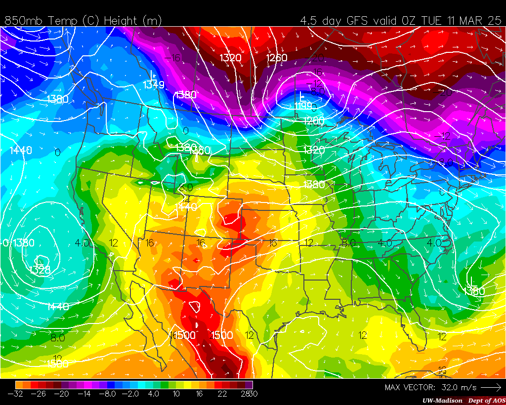
Reality: We are entering the first week of November, and the thermal structure of such a system has to be just right. Several models are showing 1-4" of snow, but the exact location, timing, and intensity will play major roles in who, if anyone, sees the white stuff by Thursday. Either way, on the back side of the clipper system, winds will shift to a more northerly direction. Cold air will be ushered in yet again for the end of the week, with even colder air than the past several days. This pattern is similar to the one forecasted in the Midwest Weather Winter Forecast. Below is the 850mb temperatures with wind vectors super imposed, notice the flow from Canada all the way south to the Gulf Coast.
Tuesday, October 28, 2014
OFFICIAL 2014-2015 MIDWEST WEATHER WINTER FORECAST
2015-2016 Winter forecast to be released mid/late October! Be sure to bookmark this page and check back for updates.
In the meantime follow us on Facebook & Twitter
Initial thoughts signal warm winter, but what about snow? and specific regions, full forecast coming soon.
2014-2015 Forecast:
There are many factors to look at when creating a winter forecast. Distinguishing between the relevant and more successful ways to predict a long range forecast is very important. Over the past few years we have found the best indicators for the upcoming winter and will explain their influence on Midwest weather. The following will examine the main factors and we will out it all together in the end of this post as our winter forecast.
The Siberian Snow Pack:
So let's begin....with Siberian snow cover with one of the easiest factors to understand. Simply put, more snow in Siberia, the colder of a North American winter. Because weather flows around the planet at an arguably 25 day rate (see LRC Cycle), it is only natural to examine the characteristics of what is upstream of the Midwest. Snow cover in this region increases the albedo (a measure of reflectivity). The increase in reflectivity of the sun's radiation surely leads to a decrease of temperature in Russia. This will in turn lead to more snow, and even more reflected radiation back into space. The cycle, we call winter, has started early for Russia and is even more pronounced than it was at this time last year (using October 23rd data). The Polar jet then advects this colder air into Canada, decreases the temperatures in the area and increases snow cover. The increase in snow cover over Canada tends to increase the magnitude of cold shots, by the same principal and the Russian snow pack.
Analog Years:
While the former made a decent case for a cold winter, there are several other (larger) factors in whether the winter will be above or below normal. Let's dive into, with arguably, the most efficient and accurate method to seasonal prediction...analog years (which are basically years that recorded similar atmospheric conditions and values as this year).
The best analog years: 1958-1959, 1960-1961, 1977-1978, 1978-1979, 2003-2004, 2009-2010.
The winter of 1978-1979 was a brutally cold winter across the eastern half of the country, and came after a already cold winter (1977-1978) hmm, coincidence? The following uses a analog climate modeler through NOAA, which can be found at This Page.
As you can see above, the analog years really put a grip on the Eastern half of the country in terms of cold and cold shots. It is actually a similar result to the Last Year's Midwest Weather Winter Forecast, which had success, especially in terms of temperature.
ENSO Factors (La nina/El nino):
Possibly one of the more well known and highly used season predictor, ENSO (the temperature of the Pacific Ocean near equatorial regions. La nina being a cooler than normal water temperatures and El nino being warmer than normal. Over the past few months there has been a decent amount of El Nino hype in the weather community as computer models were showing a increase in temperature over the key regions. It never materialized, and we currently sit at an exact average, or neutral stage. Below is the typical pattern of a neutral winter:
The CPC and other computer models poke to the idea that a light El Nino will form for the winter. Even if this pans out, ENSO values will still be near 0.0 and the above pattern seems likely. A great example comes from just year, where an El Nino was predicted, but was never a major one with values topping out around -0.6. The exact ENSO values for the winter are unknown, but either way I expect a neutral like pattern across the Midwest this winter!
Above is a plot of temperature in El Nino years for Madison, as example. Notice the weak el nino has minimal correlations for the average temperature across the region. It is important to take more in account than just the ENSO, as evident by the plot above.
Great Lakes Water Temperatures:
Another, more localized, player in the upcoming winter is the sea surface temperatures of the Great Lakes. A product of the past winter, all five of the Great Lakes are running well below normal in terms of average water temperature. On the right is water temperatures of Lake Superior, for example, notice the 2014 plot compared to the past 5 years. It is well below average and the trend of the past five years. Without using water temperature models, a simple interpolation suggests water temperatures will continue to stay below average and on par of this past winters water temperatures.
We will use Lake Superior as another example, as it the largest and most upstream to weather patterns. The plot on the right (from GLERL) shows the historic average and 2014 values over time. Water temperatures have yet to recover from this past winter and Remember this?, Lake Superior still had ice sheets in June! While it has retreated closer to the 22 year average, computer models project water temperatures to decrease in the coming weeks to follow the general trend of 3-6 degrees below normal.
If you have ever stood by a lake during the springtime with a onshore breeze, you certainly understand the effect a lake can have on local weather. The larger the lake the larger the effect. In the fall the Great Lakes actually keep surrounding states warmer, as the water cools slower than the land, so winds will blow warmer air over the surface. However, subtract 3-6 degrees from the water temperature and a whole different story is told. The Great lakes will simply lose a degree or so from the cooler lakes than usual. At the same time, lakes will freeze over more quickly, which will limit the lake effect snow machine. We still expect near average snow in the snow belt regions of the Great Lakes.
The Final Product:
Here it is...the official forecast. Below normal temperatures are favored throughout all of the Midwest. With a southeast flowing jet, the regions with the highest probability of colder than normal are indicated in the darker shades. For precipitation, expect a near average total, with above average favored further south. However, similar to our analog years, snowfall will likely be above normal by virtue of the ratio of snow to rain. An active "Alberta Clipper" pattern could set up after an established snow pack in January.
Be sure to like our Facebook Page for more updates throughout the winter
In the meantime follow us on Facebook & Twitter
Initial thoughts signal warm winter, but what about snow? and specific regions, full forecast coming soon.
2014-2015 Forecast:
There are many factors to look at when creating a winter forecast. Distinguishing between the relevant and more successful ways to predict a long range forecast is very important. Over the past few years we have found the best indicators for the upcoming winter and will explain their influence on Midwest weather. The following will examine the main factors and we will out it all together in the end of this post as our winter forecast.
The Siberian Snow Pack:
So let's begin....with Siberian snow cover with one of the easiest factors to understand. Simply put, more snow in Siberia, the colder of a North American winter. Because weather flows around the planet at an arguably 25 day rate (see LRC Cycle), it is only natural to examine the characteristics of what is upstream of the Midwest. Snow cover in this region increases the albedo (a measure of reflectivity). The increase in reflectivity of the sun's radiation surely leads to a decrease of temperature in Russia. This will in turn lead to more snow, and even more reflected radiation back into space. The cycle, we call winter, has started early for Russia and is even more pronounced than it was at this time last year (using October 23rd data). The Polar jet then advects this colder air into Canada, decreases the temperatures in the area and increases snow cover. The increase in snow cover over Canada tends to increase the magnitude of cold shots, by the same principal and the Russian snow pack.
Analog Years:
While the former made a decent case for a cold winter, there are several other (larger) factors in whether the winter will be above or below normal. Let's dive into, with arguably, the most efficient and accurate method to seasonal prediction...analog years (which are basically years that recorded similar atmospheric conditions and values as this year).
The best analog years: 1958-1959, 1960-1961, 1977-1978, 1978-1979, 2003-2004, 2009-2010.
The winter of 1978-1979 was a brutally cold winter across the eastern half of the country, and came after a already cold winter (1977-1978) hmm, coincidence? The following uses a analog climate modeler through NOAA, which can be found at This Page.
As you can see above, the analog years really put a grip on the Eastern half of the country in terms of cold and cold shots. It is actually a similar result to the Last Year's Midwest Weather Winter Forecast, which had success, especially in terms of temperature.
ENSO Factors (La nina/El nino):
Possibly one of the more well known and highly used season predictor, ENSO (the temperature of the Pacific Ocean near equatorial regions. La nina being a cooler than normal water temperatures and El nino being warmer than normal. Over the past few months there has been a decent amount of El Nino hype in the weather community as computer models were showing a increase in temperature over the key regions. It never materialized, and we currently sit at an exact average, or neutral stage. Below is the typical pattern of a neutral winter:
The CPC and other computer models poke to the idea that a light El Nino will form for the winter. Even if this pans out, ENSO values will still be near 0.0 and the above pattern seems likely. A great example comes from just year, where an El Nino was predicted, but was never a major one with values topping out around -0.6. The exact ENSO values for the winter are unknown, but either way I expect a neutral like pattern across the Midwest this winter!
Above is a plot of temperature in El Nino years for Madison, as example. Notice the weak el nino has minimal correlations for the average temperature across the region. It is important to take more in account than just the ENSO, as evident by the plot above.
Great Lakes Water Temperatures:
Another, more localized, player in the upcoming winter is the sea surface temperatures of the Great Lakes. A product of the past winter, all five of the Great Lakes are running well below normal in terms of average water temperature. On the right is water temperatures of Lake Superior, for example, notice the 2014 plot compared to the past 5 years. It is well below average and the trend of the past five years. Without using water temperature models, a simple interpolation suggests water temperatures will continue to stay below average and on par of this past winters water temperatures.
We will use Lake Superior as another example, as it the largest and most upstream to weather patterns. The plot on the right (from GLERL) shows the historic average and 2014 values over time. Water temperatures have yet to recover from this past winter and Remember this?, Lake Superior still had ice sheets in June! While it has retreated closer to the 22 year average, computer models project water temperatures to decrease in the coming weeks to follow the general trend of 3-6 degrees below normal.
If you have ever stood by a lake during the springtime with a onshore breeze, you certainly understand the effect a lake can have on local weather. The larger the lake the larger the effect. In the fall the Great Lakes actually keep surrounding states warmer, as the water cools slower than the land, so winds will blow warmer air over the surface. However, subtract 3-6 degrees from the water temperature and a whole different story is told. The Great lakes will simply lose a degree or so from the cooler lakes than usual. At the same time, lakes will freeze over more quickly, which will limit the lake effect snow machine. We still expect near average snow in the snow belt regions of the Great Lakes.
The Final Product:
Here it is...the official forecast. Below normal temperatures are favored throughout all of the Midwest. With a southeast flowing jet, the regions with the highest probability of colder than normal are indicated in the darker shades. For precipitation, expect a near average total, with above average favored further south. However, similar to our analog years, snowfall will likely be above normal by virtue of the ratio of snow to rain. An active "Alberta Clipper" pattern could set up after an established snow pack in January.
Be sure to like our Facebook Page for more updates throughout the winter
Sunday, October 26, 2014
Hurricane Ana Remnants to Amplify Halloween Cold Spell
On the right we have a 24 hour height tendency off the European model from Penn State E-Wall. In a typical pattern we have a ridge, trough, ridge, trough and so on. However, vorticity (a measure of spin) from Ana is noted in the model and can be seen as the small "kinks" in the area circled. While Ana will not have a noticeable effect on weather over Montana and points south, it will affect the pattern at upper levels for the eastern half of the country, which will have an effect on temperatures across the region by the end of the week.
While models were showing a large ridge over the eastern half of the country the past few days by the end of the week, a complete opposite is now the norm in the models. The GFS and EURO are lagging behind with the unusual influence of Ana in Pacific Ocean. The GFS and EURO are both showing this profound trough over the Midwest and points east by Halloween. The trough will allow the significant surge of colder Canadian air to filter in. Imagine pushing down on a pool of water and building your own "trough," the discontinuity made will fill in with an attempt to reach a balance.
Here are the 850mb temperatures off the GFS (left) and European (right) computer models. The robust GFS has temperatures of 10-14C below zero over the Great Lakes, which translates to high temperatures in the 30s. The Euro has highs in the 40s and 50s for the same region. No matter what model proves to be fully accurate, a below normal Halloween should be expected. I would expect the Official CPC 6-10 Day Outlook to be updated in the coming days to reflect this shot of colder air.
While models were showing a large ridge over the eastern half of the country the past few days by the end of the week, a complete opposite is now the norm in the models. The GFS and EURO are lagging behind with the unusual influence of Ana in Pacific Ocean. The GFS and EURO are both showing this profound trough over the Midwest and points east by Halloween. The trough will allow the significant surge of colder Canadian air to filter in. Imagine pushing down on a pool of water and building your own "trough," the discontinuity made will fill in with an attempt to reach a balance.
Here are the 850mb temperatures off the GFS (left) and European (right) computer models. The robust GFS has temperatures of 10-14C below zero over the Great Lakes, which translates to high temperatures in the 30s. The Euro has highs in the 40s and 50s for the same region. No matter what model proves to be fully accurate, a below normal Halloween should be expected. I would expect the Official CPC 6-10 Day Outlook to be updated in the coming days to reflect this shot of colder air.
Saturday, October 25, 2014
Once a Hurricane, Ana has its Sights set on British Columbia
Once Hurricane Ana will transition into and ex-tropical system and make "landfall" in Canada! This is certainly a rare event. Some of the remnants will be advected into the Midwest by late next week, and will have an effect on our weather. (post coming Sunday morning) There has never been a tropical system that held its characteristics long enough and made landfall on the Pacific side of Canada. It still appears Ana will transition from a warm core system to a cold core, deeming it extratropical. However, it will be something to watch for as we head into the beginning of next week, when landfall (either tropical or ex-tropical) of Ana occurs!
Winter Forecast Announcement
OFFICIAL MIDWEST WEATHER WINTER FORECAST to
be released Tuesday evening (Oct. 28th)! Just how similar
will it be to last year's record breaking year??
be released Tuesday evening (Oct. 28th)! Just how similar
will it be to last year's record breaking year??
Pleasant Weather Across the Midwest Saturday
![]() |
| 17z Surface Analysis |
Friday, October 3, 2014
Early October Snow, say it aint snow
Light to moderate snow has been reported in Northwestern Wisconsin during the overnight hours! The snow is expected to drop south overnight and eventually pivot around a strong area of low pressure to the east during the early morning hours on Saturday, any accumulation will be light. May we remind you its October...5 days ago many of these locations will in the 80s!
The first map below is of the HRRR (experimental run) of total snowfall over the next 14 hours! It has a pretty good handle on how this system is evolving.
Finally, the last map is of 850mb temperatures for 6z Saturday. It is showing the expansive cold encompassing much of the Midwest. Record low maximums are in jeopardy Saturday! The well below normal temperatures appear to hold strong right on through the next week and beyond.
The first map below is of the HRRR (experimental run) of total snowfall over the next 14 hours! It has a pretty good handle on how this system is evolving.
Finally, the last map is of 850mb temperatures for 6z Saturday. It is showing the expansive cold encompassing much of the Midwest. Record low maximums are in jeopardy Saturday! The well below normal temperatures appear to hold strong right on through the next week and beyond.
Subscribe to:
Posts (Atom)


.gif)