
Tuesday, December 19, 2017
Midwest Snow Event by Late-Week
Monday, December 18, 2017
Midwest Weather Winter Storm Update

Saturday, December 16, 2017
Pre-Christmas Winter Storm Possible across Midwest


5pm Monday: Click Here for an update
Tuesday, December 12, 2017
Quick Hitting Snowfall Wednesday


Thursday, November 30, 2017
2017-2018 Midwest Weather Winter Forecast
After a cool start to a November that produced a couple rounds of light snow across the Upper Midwest, the latter half of the month has been well above normal across the Midwest. With the warm weather taking hold, people are asking, "What does it mean for the winter?" While there is little correlation to how the weather in November determines the rest of the season, yet there are methods meteorologists can use to gather insight on what to expected through March. With meteorological winter starting tomorrow (December 1st), it is finally time to unveil the official Midwest Weather winter outlook for the 2017-2018 season.
2016-2017 Winter Recap:

To jive your memory, let's take a look at last winter. It featured a neutral ENSO to near-weak La Nina, meaning the ocean temperatures in the equatorial Pacific Ocean were near normal or slightly below normal. When neither a La Nina or El Nino develops, other climatic processes carry more weight and will have more of an impact on the weather across the United States. Above is a look at temperatures and rain/snow amounts compared to average. According to the Midwestern Regional Climate Center, the Midwest saw temperatures run a few degrees above normal, with precipitation dependent on two storm tracks that brought above normal rain/snow amounts from Iowa into parts of Wisconsin, and kept other parts of the region below average. The winter forecast posted Last Year, panned out fairly well. With the 'increased risk for larger storms' in the upper midwest, 'below average snow' in the Mid-Mississippi River Valley, along with 'increased lake effect' the forecast generally held up. The temperatures ended up warmer due to a very warm second half of February, with record highs ruled the land.
Now let's take a look at what to expect for this upcoming winter. Using current conditions of the oceans and atmosphere can work to forecast upcoming winter conditions. Four climate processes will be examined to determine what are called analog years, or years that are most similar to this upcoming winter. The status of ENSO, PDO, QBO, and AMO will be studied and compiled to develop our winter forecast!
ENSO (La Nina/El Nino):
 Climate models and trends are suggesting that a La Nina is in the process of developing for this winter. Typically when the index is more negative than -0.5, a La Nina is then classified. While we are expecting a cooler than normal equatorial Pacific, it will not be extensively cool. Model consensus is expecting the status of ENSO to run about -0.8 through much of the winter. Below is a higher time step resolution, with the current value measured at near -0.8, yet will fluctuate day to day.

The Pacific Decadal Oscillation (PDO):


A visual representation of the PDO flipping to the cold phase is above, current sea surface temperatures, via tropical tidbits. Notice the blob of warmer than average SSTs in the Northern Pacific, with pockets of cooler than average SSTs in the vicinity of the Gulf of Alaska. Its subtle, but does match the cold phase of the PDO in the image above better than the warm phase. In our analogs, we will use a slightly negative PDO value throughout the winter.
The Atlantic Multidecadal Oscillation (AMO):
The AMO is a similar process in the North Atlantic, yet on longer time scales. It has been in the warm phase for a couple decades now, and is expected to continue through winter. We will use positive values for collection of analog years.

Quasi-Biennial Oscillation (QBO):
The QBO is a oscillation in the wind direction within 15 degrees of the equator. It tends to have a periodicity of nearly 2 years and is currently settling into a negative phase.
 Above is a look at the variation of the QBO, notice the flip to negative just this Fall, with the trend of more negative values to continue based on history. For our analogs, we will use increasingly negative QBO values through the winter months.
Developing Analog Years:
We will then use each of the four climate values as predictors, normalized to equal magnitude.
ENSO: Slightly Negative (Double weighted)
PDO: Slightly Negative
AMO: Positive
QBO: Negative
A database was set up with each index from every month back to 1950. Below are the expected values for December through February, with the months/years in the past that are closest fit.
Below is a look at expected values for ENSO/PDO/QBO/AMO and the closest corresponding years:

Here is a look at how these years were compared to average in temperatures and precipitation:
 Below is a look at expected values for ENSO/PDO/QBO/AMO and the closest corresponding years:
 Here is a look at how these years were compared to average in temperatures and precipitation:
 Below is a look at expected values for ENSO/PDO/QBO/AMO and the closest corresponding years:
 Here is a look at how these years were compared to average in temperatures and precipitation:

So What does this all mean for the Midwest?
Based on the analog years, the winter of 2017-2018 looks to start with a cool December, trend to a warmer than average January and possibly head back to a near or slightly below normal February. The highest confidence in the forecast is during December and February. January is a little more tricky since the top year (1963) was a cold month for the entire country, yet the rest of the analog months came back as warm. A breakdown in the polar vortex could send cold air spewing south (like it did in January of 1963), but it could easily end up in Europe or Asia. While January looks to either go very cool or warm, odds suggest the warm scenario will pan out with 4 of 5 analog years fitting this idea.
Official forecast below!
Thanks for reading! Be sure to follow on Twitter and 'like' on Facebook for updates through the winter. Feel free to send any questions, twitter will be the best place for
this.

2016-2017 Winter Recap:

To jive your memory, let's take a look at last winter. It featured a neutral ENSO to near-weak La Nina, meaning the ocean temperatures in the equatorial Pacific Ocean were near normal or slightly below normal. When neither a La Nina or El Nino develops, other climatic processes carry more weight and will have more of an impact on the weather across the United States. Above is a look at temperatures and rain/snow amounts compared to average. According to the Midwestern Regional Climate Center, the Midwest saw temperatures run a few degrees above normal, with precipitation dependent on two storm tracks that brought above normal rain/snow amounts from Iowa into parts of Wisconsin, and kept other parts of the region below average. The winter forecast posted Last Year, panned out fairly well. With the 'increased risk for larger storms' in the upper midwest, 'below average snow' in the Mid-Mississippi River Valley, along with 'increased lake effect' the forecast generally held up. The temperatures ended up warmer due to a very warm second half of February, with record highs ruled the land.
Now let's take a look at what to expect for this upcoming winter. Using current conditions of the oceans and atmosphere can work to forecast upcoming winter conditions. Four climate processes will be examined to determine what are called analog years, or years that are most similar to this upcoming winter. The status of ENSO, PDO, QBO, and AMO will be studied and compiled to develop our winter forecast!
ENSO (La Nina/El Nino):


The Pacific Decadal Oscillation (PDO):

The PDO is another dynamic ocean pattern on a longer time scale than ENSO. Typically it can change from phase to phase over the course of a decade or longer. The PDO has been in the warm phase over the past several years, yet there are signs it may lean to the cool side this winter or hover around neutral. The latest observed value was -0.62, down from values near 0 earlier in the Fall.

The Atlantic Multidecadal Oscillation (AMO):
The AMO is a similar process in the North Atlantic, yet on longer time scales. It has been in the warm phase for a couple decades now, and is expected to continue through winter. We will use positive values for collection of analog years.

Quasi-Biennial Oscillation (QBO):
The QBO is a oscillation in the wind direction within 15 degrees of the equator. It tends to have a periodicity of nearly 2 years and is currently settling into a negative phase.

Developing Analog Years:
We will then use each of the four climate values as predictors, normalized to equal magnitude.
ENSO: Slightly Negative (Double weighted)
PDO: Slightly Negative
AMO: Positive
QBO: Negative
A database was set up with each index from every month back to 1950. Below are the expected values for December through February, with the months/years in the past that are closest fit.
Below is a look at expected values for ENSO/PDO/QBO/AMO and the closest corresponding years:

Here is a look at how these years were compared to average in temperatures and precipitation:


In both December and February the top 3 years were used. In January the top 5 years were used due to the large differences in a cold 1963 and warmer other similar years. In February the top 3 years were used, with more weight given to 2012 since it was much closer to expected conditions than the next closest year.
So What does this all mean for the Midwest?
Based on the analog years, the winter of 2017-2018 looks to start with a cool December, trend to a warmer than average January and possibly head back to a near or slightly below normal February. The highest confidence in the forecast is during December and February. January is a little more tricky since the top year (1963) was a cold month for the entire country, yet the rest of the analog months came back as warm. A breakdown in the polar vortex could send cold air spewing south (like it did in January of 1963), but it could easily end up in Europe or Asia. While January looks to either go very cool or warm, odds suggest the warm scenario will pan out with 4 of 5 analog years fitting this idea.
Official forecast below!
Thanks for reading! Be sure to follow on Twitter and 'like' on Facebook for updates through the winter. Feel free to send any questions, twitter will be the best place for
this.

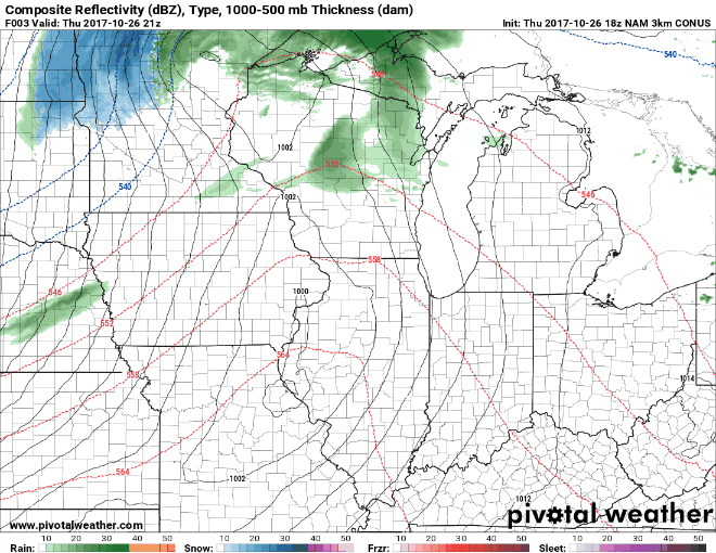
Thursday, October 26, 2017
The First Snow of the Season

A strong clipper system will slide south from Canada tonight, bringing just enough cold air to support snow across much of Minnesota and the Upper Peninsula of Michigan. Most of the snow will pile up west of I-35, with a few inches are expected. Snow will still fall in parts further east, but will struggle to accumulate, with temperature above freezing and ground temperatures in the lower 50s. Below is one model's rendition of how this system may pan out over the next 48 hours. Notice the heavier band work through the Minneapolis metro during the afternoon on Friday, some moderate to briefly heavy snow is possible for a period.
Welcome to the start of winter! Look for this blog to become more active over the next 4-6 months. There are some hints of a larger system during the second week of November, so stay tuned to Midwest Weather on Facebook and on Twitter for continued updates.
Friday, April 28, 2017
Winter's Last Stand?


Monday, February 20, 2017
Significant Winter Storm Expected Friday

An upper level trough is expected to swing into the northern Plains late week, allowing for the ushering in of colder air from the north. The anticipated storm system will track along this boundary of cold to warmer air, taking it into the Midwest by Friday. Furthermore, a deepening of the low pressure and a high pressure to the north and west will act to increase winds on the back side of the system Friday night into Saturday. It is not impossible for some locations to reach blizzard criteria Friday night. Lots to work out in the next few days, feel free to follow on Twitter and 'like' on Facebook for more frequent updates.
We are also likely headed into a more active wintry pattern, with a couple chances for larger winter storms through early March, stay tuned!
Here is one model's take on the coming storm. Powered by Pivotal Weather.

Tuesday, January 31, 2017
Large Winter Storm to Unleash Bitter Cold


Monday, January 23, 2017
Accumulating Snow Expected To Develop Tonight

Light to moderate snow is expected to develop over the northern Plains later tonight into Tuesday. The snow will linger into Wednesday for parts of the Upper Midwest. This system will deepen tonight, then weaken as it passes to the east over the next couple days. Consequently, the heaviest snowfall will stay in western sections of the region, across South Dakota, but a solid 3-7" of snow will set up east towards Wisconsin. Total snow of 4-5" amounts will be common, but a narrow band of up to 7-8" will fall where the more persistent snow bands line up. Questions still arrive in how much rain and sleet will mix in across southeastern Wisconsin, with a lot of snow coming during the day for much of Wisconsin, snow accumulation on pavements will be somewhat limited, as grassy surfaces will pick up more snow. Below is the total snowfall you can expect over the next couple day, with slightly less on roadways for those that see more snow during the day, as temperatures will hover around freezing. Be sure to follow on Twitter and Facebook for more weather tidbits and updates.

Sunday, January 22, 2017
Accumulating Snow Returns To Midwest Early Week

Subscribe to:
Comments (Atom)