ShareThis

Tuesday, December 31, 2013

Updated Snowfall Map for Today into Tomorrow

Computer models are now coming together on a strong Alberta Clipper headed our way today. The snow has already began to fall and will continue through the night in most places. It will be moisture stricken, but with such a cold air mass holding its own, it will not take much to fluff up several inches of snow. Right now it is looking like a Chicago special, in terms of heavy snow. A broad area of 3-6" can be expected, but a very narrow band of heavy snow will set up likely from Lake Erie to Chicago. Furthermore, lake enhanced snow will be seen along the SW coast of Lake Michigan where 8,9" is not out of the question. You can follow us on twitter, or like of Facebook page, information for that is on the right side of the page! Happy New Year's everyone! 

Monday, December 30, 2013

Narrow Band of Heavy Snow in Hit New Year Eve

Computer models are now coming together on a strong Alberta Clipper headed our way for Tuesday night (New Years Eve). It will be moisture stricken, but with such a cold air mass holding its own, it will not take much to fluff up several inches of snow. Right now it is looking like a Chicago special, in terms of heavy snow. A broad area of 3-6" can be expected, but a very narrow band of heavy snow will set up likely from Lake Erie to Chicago. Furthermore, lake enhanced snow will be seen along the SW coast of Lake Michigan where 10" is not out of the question. You can follow us on twitter, or like of Facebook page, information for that is on the right side of the page! Happy New Year's everyone!

Sunday, December 29, 2013

Heavy Snow, a Real Possibility on New Year's Day!

Storm number 2 this week, and it could be the big one! An Alberta Clipper with an upper level low pressure associated with it will squeeze an ample amount of moisture in parts of the Midwest. Computer models are still struggling on the placement on amounts of snow this system will drop. With the cold air mass in place, all of the precipitation will be snow and will pile up quickly with high water to snow ratios...leading to a light and fluffy snow yet again. With the overall flow and model runs over the past couple days, the best best for heavy snow will be along an axis from Detroit to Milwaukee and points west. 6"+ of snow is not out of the question as this storm has the potential to be a "winter storm warning" criteria. The question will be how organized a deformation zone (if it happens) can set up and how concentrated the relatively limited moisture can be. Please stay tuned for updates on this possible New Years Day winter storm! We will put together a snow map once models are in agreement!


The Beginning of an Active Pattern for the Midwest?

A series of Alberta Clippers ranging in intensity will be the story in the world of weather for the Midwest, at least for the next week or so. Let start with the first system. It is already developing near the Pacific Ocean, however will not carry much moisture with it. Most totals will be around an inch of fluffy snow by Tuesday morning. With temperature in the single digits, road crews will face difficulties as most salt treatments will not work at such low temperatures, leading to a slick commute Monday evening and Tuesday morning.

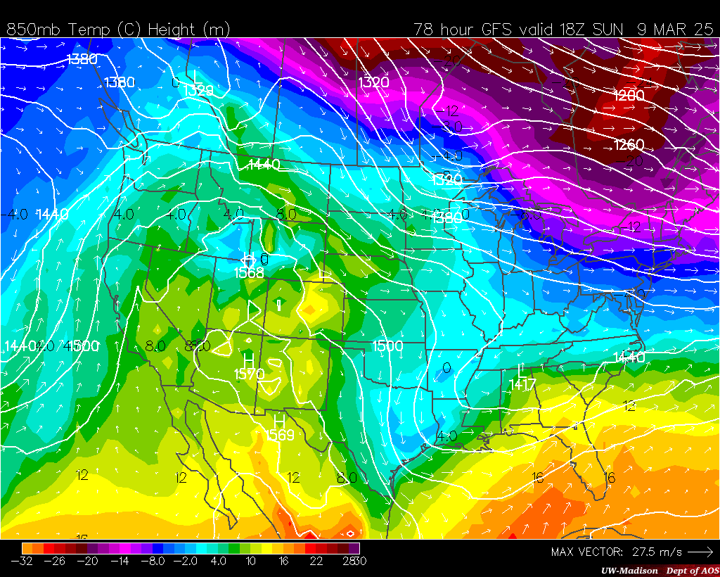
Here Come the Boom: Piercing Cold Ahead

A cross country arctic blast is making its presence known this afternoon. The front has now made its way through much of the Midwest and will continue to press eastward. Behind the from you can expect winds to shift to  more northwesterly direction. With a clear fetch to northern Canada, some of the coldest air on the continent will make its way south.  With high pressure building, clear skies can be expected tonight, which will lead to a very cold night. Without a layer of clouds to acts as a blanket to the atmosphere, warm air will rise, and surface temperatures will fall below zero!
Wind chill advisories have been issued for all of Wisconsin, Minnesota, much of Iowa and surrounding states (see map on right). The combination of extreme cold and light winds, wind chill indices will plummet to 30-40-50 below zero.

Along with the surge of cold air, an active pattern will set up across the Midwest this week. Look for a post on that later this evening when new data comes in.

Saturday, December 28, 2013

A Blast of Arctic Air Just in Time for New Years

The coldest air of the season will surge into the Midwest on Saturday and Sunday. As for Saturday, "warm" weather will be the story as highs in the 40s, 50s, and 60s will take hold ahead of the front. Enjoy the nice weather while it lasts! One thing to watch for: As the snow melts and puddles on roadways, a possible flash freeze is possible as the front cools things down rapidly. As the colder air moves through (Saturday night into Sunday for most places) a few snow showers are also possible with a dusting to an inch possible from Minnesota to Michigan.


As for Sunday: Most of you will see your high temperature in the early morning before the front moves through later in the day. Temperatures will drop throughout the day. Winds will shift from the south to the north and wind chills will become a problem on Sunday afternoon. The combination of winds and cold temperatures winds will drop below zero by the evening, in most places.
By Monday, the arctic air will have settled in. Many neighborhoods in the northern half of the Midwest will struggle to reach zero as a high temperature! Wind chill advisories and warnings will will certainly be issued, with indices approaching 50 below in some places, especially in the darker blue shading on the map.

Much of the same for Tuesday. As you head out for New Years Eve celebrations, bundle up, and bring necessary gear to stay warm just in case your car breaks down.


Tuesday Afternoon:


High Temperatures by Tuesday:


Friday, December 20, 2013

WEEKEND WINTER STORM TO IMPACT HOLIDAY TRAVELS

We are starting to close in on the main event, the expansive winter storm for the Midwest. We have been tracking this system for 6+ days now, and confidence is finally considerably high on the track and snow amount of this storm. Winter storm watches have already been issued from Nebraska to Green Bay. The main story will be the snow here, but a major severe weather outbreak will occur this weekend in the deep south, demonstrating the strength of this low pressure system!

Storm Summary: A major ridge has developed in the Southern Rockies, with a strong split flow in place. This feature is very conducive to winter storms in our area. With this pattern in place, a strong surface low pressure will develop near Texas and race northeast into northern Indiana by Sunday, dropping significant snows on the back side of the system in a stretched out deformation zone (classic to such a winter storm).

Forecast: The heaviest snow amounts still appear to be on the order of 5-9" with locally higher amount. Some models are actually hinting at a foot of snow in some spot, but whether that materializes will depend on whetehr or not we can get the severe thunderstorms to rotate back into the cold, and fall as all snow.  

One thing I would like to mention, is the the exact track and exact location of the axis of heavy snow is not set in stone (although were are fairly confident) the 5-9" band is subject to a north or south shift by 10-30 miles. So stay tuned for updates!

Thursday, December 19, 2013

The Main Event Closing in: Major Midwest Winter Storm

We are starting to close in on the main event, the expansive winter storm for the Midwest. We have been tracking this system for 5+ days now, and confidence is finally considerably high. Winter storm watches have already been posted  for much of the threat area!

Storm Summary: A major ridge has developed in the Southern Rockies, with a strong split flow in place. This feature is very conducive to winter storms in our area. With this pattern in place, a strong surface low pressure will develop near Texas and race northeast into northern Indiana by Sunday, dropping significant snows on the back side of the system.

Forecast: The heaviest snow amounts still appear to be on the order of 6-10", where that exact band sets up is somewhat in question, as models are not fully in unison. However, our confidence is on the rise that this band will fall close to the red shaded area. With lesser amounts from there. We should have a preliminary snow map up tomorrow afternoon, as storm sampling comes in. We will sift through the data sets and map our interpretation. Stay tuned for that!

Wednesday, December 18, 2013

Major Weekend Winter Storm Update for the Midwest

New model runs are in, with some changes to talk about. One, the track has shifted slightly to the south. Now, this track will continue to bounce around slightly until we get closer to the main event. The map you see is the best prediction we have at the moment. With a split flow in place over the southern Rockies, we may be in for quite the storm.  It will really depend on how organized the systems energy can get before becoming a full mid-latitude cyclone somewhere near Chicago or northern Indiana. Models have struggled with this feature significantly.  With that in mind...total amounts are also up in the air, with some models saying 5-8" while others put down near a foot of snow, with enhancement in eastern Wisconsin of Lake Michigan.

The storm is just making it onshore now on the Pacific Coast, so we should be able to get better data by tomorrow.  Our weather computer models will have all the data they need to settle in on a solution in the next couple days. 

A few concerns on the forecast:

1) Amounts! Unfortunately models are struggling with what will be rain and what will be snow. In other words, what percent of the storms precipitation will be snow and what percent will be rain. This leads to model differences of storm putting down 4-8" or maybe 6-12"+

2) How much will thunderstorms in the south take away from our moisture, or will they rotate into the cold air and really get that snow to add up quickly?

3) The track continues to waffle, which will have MAJOR effects on who sees the heavy snow band and who sees the rain. For example, Chicago could easily be all rain, or could see 8" of snow. We will know much more in the next 12-36 hours!

Major Winter Storm to Impact the Midwest Sunday

It has been a weather computer model battle for the past several days now, as to what and where would strike the Midwest this weekend. Well, the GFS and EURO models (European and American) have settled their argument and are agreeing on a possible solution. They are showing a band of heavy snow (winter storm warning criteria) from Nebraska all the way into Cananda. The map on the left shows the risk of seeing this band of likely 6"+ of snow as an area of low pressure deepens rapidly on Sunday to near 988mb, on par with a hurricane! You are going to want to stay tuned for this one, we will be providing constant updated on our site here and also on our facebook page, which you can "like" on the box on the right hand side of your screen.

Tuesday, December 17, 2013

Winter Storm Update

Quick update on potential winter storm this weekend. We have ourselves of northward trend in the models this morning. Here is a snow forecast off the DGEX model run this morning. Showing a healthy area of 6-12" of snow. Now, the track will continue to waffle around, so stay tuned!


UPDATE: Here is the 12z EURO run:


Monday, December 16, 2013

Major Winter Storm Possible this Weekend

MAJOR WINTER STORM?
Certainly looking more and more possible as weather computer models are starting to output the same solution. The atmosphere will be primed for heavy precipitation as a strong feed of moisture all the way from the Baja in California will be available, along with the Gulf of Mexico streaming its usual moisture, this storm has the potential to drop significant amounts of rain and snow across parts of the Midwest. But Where? Now that I have your attention...we are still 6+ days out and the timing and specific track are in question. Some models take it near Minneapolis others keep all the snow south of Chicago. We will certainly update as the storm gets closer and models are more consistent.
Not to forget about the Thursday storm...where a few inches of snow and maybe some freezing rain will be possible from Nebraska to Michigan, but nothing in comparison the possible weekend monster, stay tuned!!

Tuesday, December 10, 2013

Band of Snow to Impact Chicago Commute Tomorrow Morning

A quick hitting shortwave system will drop a few inches in some spot by tomorrow morning. Roads will become slick with the combination of snow and very cold temperature, any salt put down will have a minimal effect with it being in the single digits.

Sunday, December 8, 2013

Accumulating Snow Sunday

An upper level area of low pressure will pass through the Midwest this afternoon dropping light to moderate snow in a very cold air mass, given the cold the snow will tend to fluffy up leading to several inches of snow in most places. It looks like 3" will be a common number in Wisconsin and NE Iowa.

Wednesday, December 4, 2013

Our next winter storm?

After a major ice storm to the south the next couple days, computer models are starting to pin down a moderately strong storm system that will emerge out of the Rockies on Saturday and meander to the Great Lakes by Sunday, dropping a decent amount of snow in the cold airmass to its west. With such cold air in place the snow will tend to pile up quickly, and "fluff" up. It will not take much to reach 6" of snow. Right now it is too early to pin down amounts, but it is starting to look like a solid area of 3-6" will be likely, with the best chances in the darker blue shaded region.

Monday, December 2, 2013

Winter Storm Update

Here is out updated snowfall map with more specific amounts, the discussion is unchanged, see last post post.  Enjoy the snow!